First Alert Weather: Winter storm will give way to an arctic air outbreak
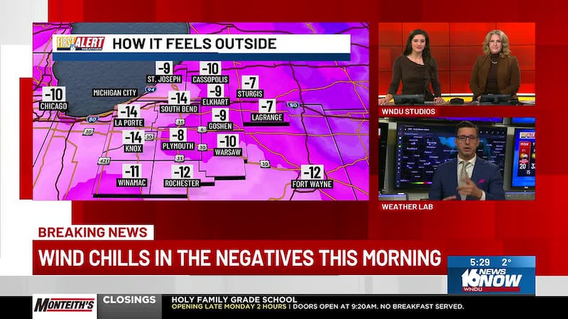
Wind chills this weekend may fall into the 20s below zero
Once again, Michiana will be the dividing line between rain and snow to start Friday’s system. Confidence is high for at least 4 inches of snowfall or more on Friday and lake effect snow on Saturday. The transition line will reduce snowfall totals for some, but impactful weather will still make travel difficult Friday night.
Confidence is very high that dangerous cold air will fill in behind our first system. Accordingly, a First Alert Weather Day(s) has been issued for Sunday, Monday and Tuesday. Depending on conditions, it’s possible this will be extended into Wednesday as well.
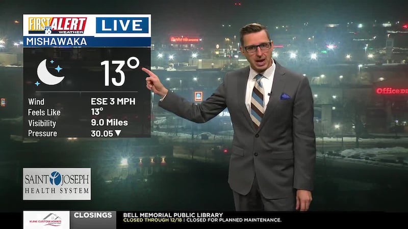
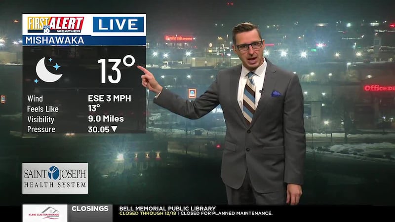
THURSDAY: Any light snow from Wednesday night ends by 9 AM Thursday. Expect a breezy day with gusts at times near 30 mph. Chance of a peek of sun in the afternoon hours. High 33F. Low 25F. Wind W 15-25 mph.
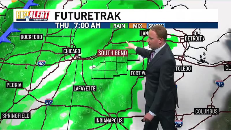
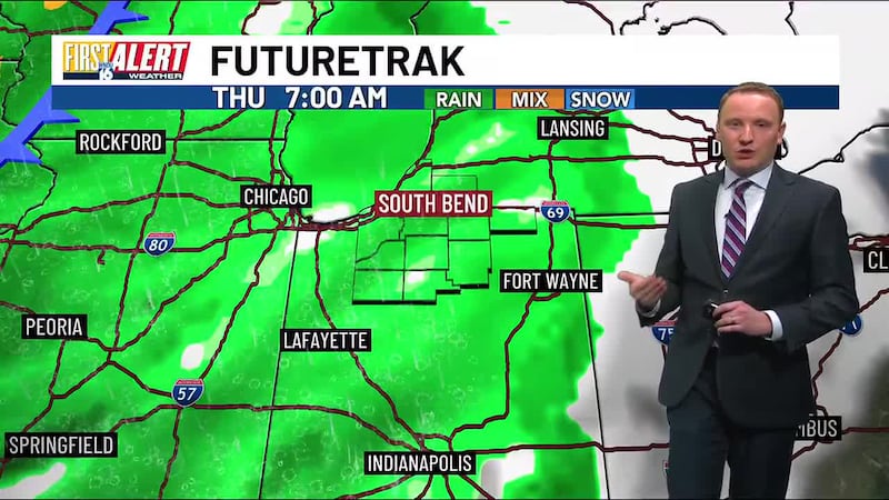
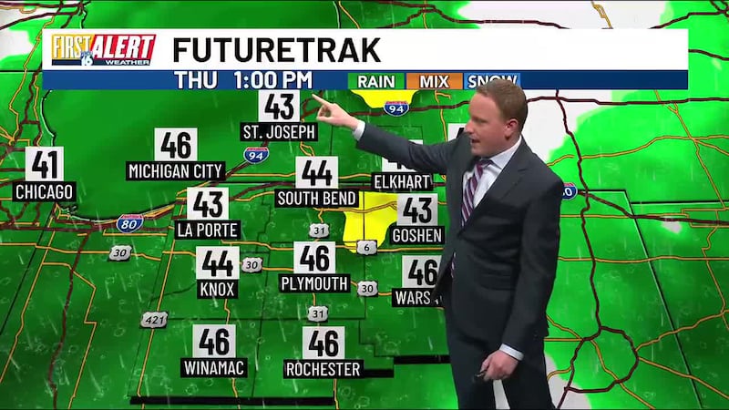
FIRST ALERT WEATHER DAY FRIDAY: Our first true winter storm of the season will impact all of Michiana Friday into Saturday. This will start out as sloppy snow/rain and then transition to times of heavy snow. Wind will be an impact as well with gusts at times of 30 to 40 mph. High around 32 to 34F. Wind SE 15-30 mph with gusts of 30-40 mph throughout the day.

- FRIDAY MORNING: Roads before 7 AM should have little to no weather impact as we await for sloppy snow and rain to move in. Sloppy snow and rain will arrive from south to north throughout the morning commute and will usher temperatures at or just above freezing. This will cause us to see a sloppy mess of snow, sleet, and rain with minimal snow accumulation.
- FRIDAY AFTERNOON: Air temperatures and exact storm track will determine where the rain and snow line sets up. Latest data suggests the rain and snow line ends up just north of Michina. This would lead to an air temperature around 33-35F and will put most of us in just plain RAIN for the bulk of the afternoon. I do not expect much in the way of snowfall accumulation during the afternoon hours for many areas and road impacts will be limited.
- FRIDAY EVENING/NIGHT: Heavy snow will overspread all of Michiana and will have area-wide travel impacts. Temperatures will go from near freezing in the evening to below freezing overnight. Friday evening and overnight is when the bulk of our snow accumulation from this winter storm is expected. Many parts of the area will receive near half foot of snow during this timeframe. Lesser amounts from Rochester/Warsaw to high amounts the closer you get to Lake Michigan.

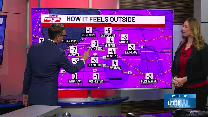
FIRST ALERT WEATHER DAY SATURDAY: Heavy system snow from Friday night will start to taper down Saturday, but blowing snow at lake effect snow will be possible. Many roads will be in tough shape with ice and snow on them. Falling temperatures should be expected from this system as cold air starts to filter into Michiana. Temperatures throughout the day will stay below freezing in the 20s. Expect temperatures in the single digits with subzero wind chills Saturday night. Wind WNW 13- 30 mph with gusts at time of 30-40 mph.
- SATURDAY MORNING: Heavy system snow starts to taper down. Roads will be in tough shape from ice and snow on them and added blowing snow.
- SATURDAY AFTERNOON: System snow ends and lake effect snow kicks in. Roads stay icy and snow covered due to temperatures staying below freezing. How much additional snow we receive from lake effect snow bands is yet to be determined.
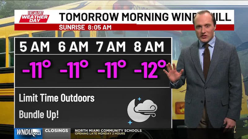
SUNDAY: Many non treated roads stay in tough shape. Highs on Sunday will stay in the single digits with subzero wind chills. Wind chills Sunday may approach -15 to -25F. Frostbite can set in as little as 15 minutes once wind chills fall into the 20s below zero!

Copyright 2024 WNDU. All rights reserved.